
- Influencing atmospheric weather patterns
- Ocean dynamics
- Phytoplankton – foundation of the marine animal life
- Conclusion
One of the most important aspects when trying to understand marginal weather events such as tornadoes, hurricanes and typhoons is the Coriolis effect.
The Coriolis effect arises when objects are moving in a rotating frame of reference in our case the earths rotation around its own axis. This rotating movement introduces some apparent deflections of the movement paths of objects. In this blogpost we will consider some of the derivative effects arising from this interesting phenomena.
Influencing atmospheric weather patterns
It’s important to realize that the apparent deflection phenomena of objects is not an introduced force meaning that the objects speed is not influenced by the Coriolis effect but instead is moving the trajectories of the objects instead.
The strength of the Coriolis effect varies according to the location on earth with its maximum happening in the polar regions of the earth and the weakest part of the effect being in the equatorial part of the world.
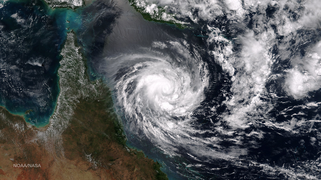
This means that when hurricanes and typhoons are formed then they are not able to cross the equator. Instead trajectories are bend either clockwise or anti-clockwise depending on the location of the low center pressure. See the pictures below for a comparison of the difference between a low pressure system in the northern hemisphere and southern hemisphere.


As can be seen from the pictures, the Coriolis effect is present and apparent rotation is dependent on the location of the low pressure center. Furthermore the entire rotational energy shifts based on the location of the low pressure where it is located in the northern or southern hemisphere.
Related read: Rossby waves causing atmospheric heat flow, Debunking Earth’s Shape: Sphere vs Flat Earth
The Coriolis effect is a global phenomena and influences every moving entity whether that be the air masses of the atmosphere or the movement of water masses of the entire earth system.
Ocean dynamics
In particular the ocean dynamics are affected by the ocean current dynamics. This means that the swirls are happening across the entire ocean and although artistic the amount of swirls is not too far from being accurate. This means that the amount of rotational energy is quite extensive across the globe.
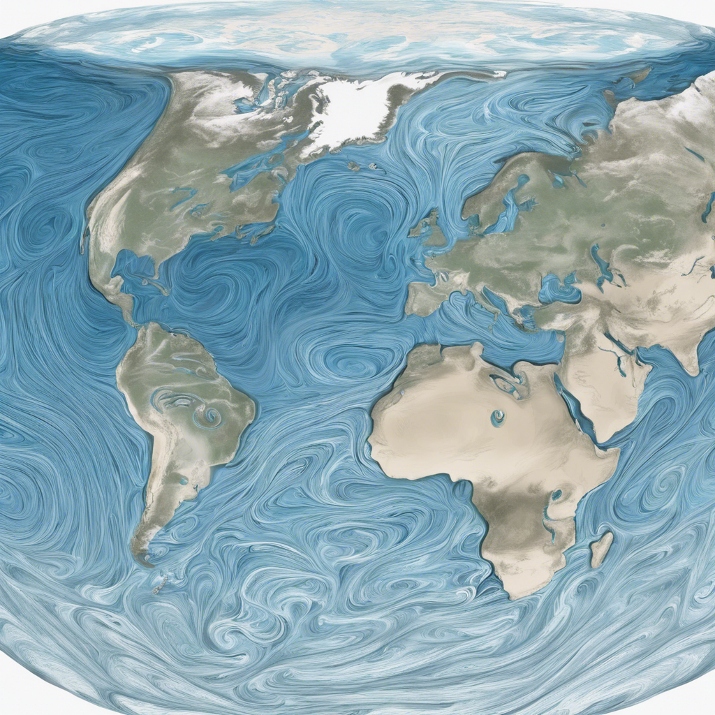
The Coriolis effect actively drives much of the water mass transport across the oceans, facilitating the exchange of massive amounts of salt and heat among different ocean domains. This interconnection significantly impacts Earth’s marine ecosystems. One notable transport stream influenced by the Coriolis effect is the Gulf Stream.
The Gulf Stream
The Gulf Stream is a crucial effect as a result of the wind driven and Coriolis effects happening across the globe resulting in the massive transport of heat and salt across the North Atlantic Ocean. This results in the development of warmer climates in the northern hemisphere ensuring that the winters are milder and summers warmer.
The moderating effect of the Gulf Stream enable climate extremes to be less intense when compared to other parts of the world in similar latitudes.
Weather impacts
Stable weather allows for the safe development of societies in a manner which enable slowly changing and improving on existing technologies. The overall positivizes of a more moderate climate contributes to northern countries stability. As natural disasters are rarely occurring as compared to similar places across the globe. Giving societies more time to mature and develop in a consistent manner.
The effects of the Gulf Stream also influences the global shipping transportation industry allowing for container ships to easily circumvent and transport goods and services across trading routes in a more efficient manner. For an accurate representation of the Gulf Stream please consult Figure 4.
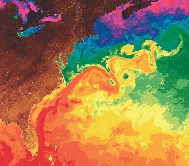
As can be seen, the Gulf Stream is a western boundary current pressuring warm salty water from the gulf coast all the way towards the northern hemisphere. The gulf is approximately 50-100 km’s wide and about 1 km deep. It moves with an average velocity of approximately 6 km/hr making it one of the fastest flowing currents across earths entire ecosystem.
Current speed
Due to its impressive speed, it has helped sailors crossing the Atlantic for hundreds of years with sailors originally utilizing a thermometer to accurately locate the Gulf Stream current ensuring that they drifted along with it across the western part of the Atlantic. This reduced travel times for goods and enhanced trade locally between sailors.
The simulation above clearly shows how the encirclement of swirls and rotations stabilizes temperature differences within the rotating spiral. This process encapsulates a cold temperature system that progresses downwards while maintaining a stable low temperature at the center of the swirl. As a result, temperature differences can exist, which would not otherwise be possible.
Scale of current eddies
The eddies can reach massive sizes, measuring up to 3.5 km deep and 500 km wide at the surface. Consequently, temperature and salinity changes within the ocean are extensive, varying dramatically across the entire depth of the water column.
The Coriolis effect drives boundary currents across the depth profile, similar to patterns observed elsewhere in the world. Variations in depth and proximity to the coast create momentum and inertia effects in the water masses, which in turn increase velocities.
The Kuroshio current
There are similarities between the Gulf Stream current and the Kuroshio current which is present in the western part of the Pacific Ocean, a location where there are quite significant depths of the bathymetry including the deepest point of the ocean floor, the Mariana trench.
The Kuroshio current is important when it comes to the differences within the marine ecosystem as the strength and direction of the current influences transport of heat, nutrients and salinity supplying ecosystems across the continent with nutritious rich contents across the entire marine food chain.
Furthermore another important effect of the Kuroshio current is its influence on extreme weather patterns which influences the entire weather system located at the coast of Japan. as the current transports heat from southern parts towards northern parts it can have the effect of fueling low pressure systems with extra energy causing increases in expected intensity of the typhoons typically ranging in that area.

As the warm water with sea surface temperature rises energy fluxes influence the atmospheric weather patterns increasing the overall energy density causing the wind speeds to increase. This increase in wind speed can lead to devastating effects when landfall is happening for the typhoons in the area.
Meteorologists use the effect of increasing and transporting heat and mass across distances near the shore to predict upcoming weather patterns, which enables early warning systems that allow citizens to disperse before disasters occur.
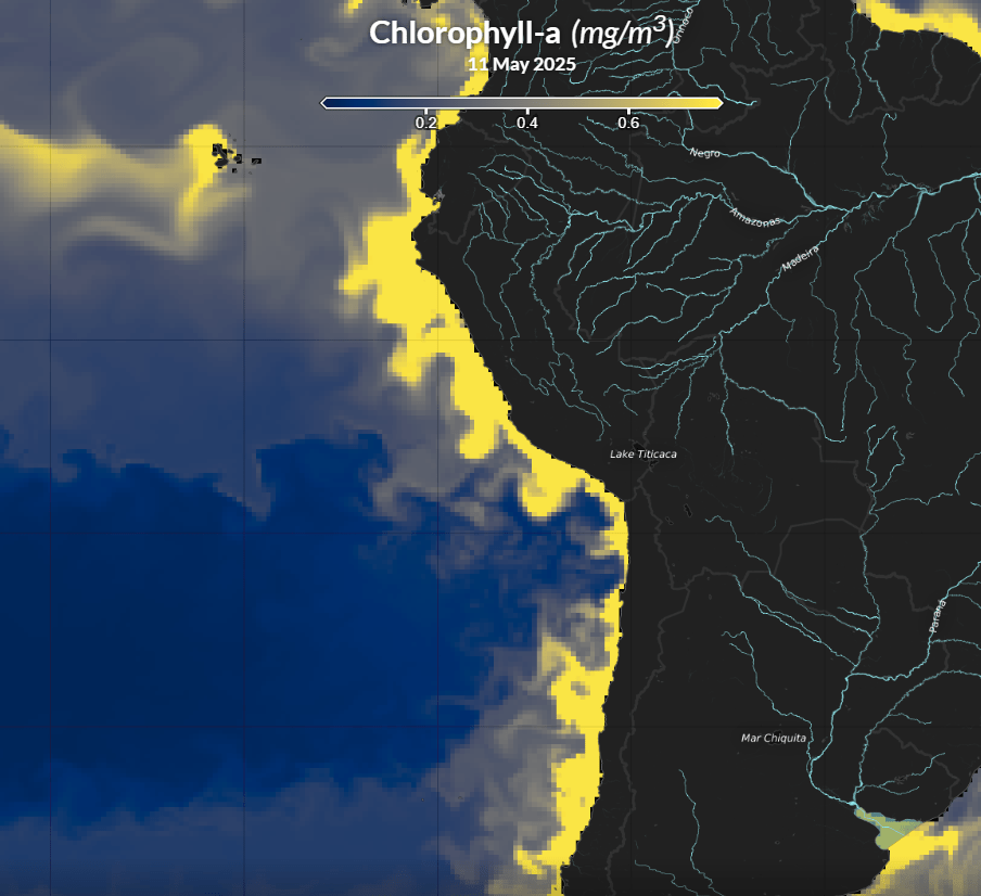
Phytoplankton – foundation of the marine animal life
Additionally, the habitats in the surrounding waters are crucially dependent on the constant exchange of nutrients, heat, salinity and oxygen caused by the continuous currents ranging from the near surface and into the upper layer of the ocean as the depth of the current is approximately 400 m’s.
Since the transport of phytoplankton is dependent upon the pathing and strength of the Kuroshio current the stability and continual existence of the current provides a foundation for the marine animal life in the area as phytoplankton is one of the foundational food sources in the food chain.
Phytoplankton density
In order to examine the differences in phytoplankton density and how the Kuroshio current transports the nutrition rich column water near the coastline of the Japanese island and further north, it is possible to map the concentration of nutritional rich water arising from the inner waters.
To assess the distribution of water, we set up and performed numerical simulations of the concentrations across the blue domain, including the inner waters surrounding the Japanese island. These simulations are accessible through the online portal Marine Copernicus, where registered users can explore various datasets, including phytoplankton concentrations. For more information, visit https://data.marine.copernicus.eu/.
I have including two different instantaneous screenshots of the distribution of phytoplankton during both the blooming environment and the nutritional poor conditions at other times of the year, see Figure 6 and Figure 7 respectively.


As the oceans warm the CO2 uptake increases leading to increased acidification of the ocean. The increased acidification of the oceans as a result of uptake of CO2 causes an increasing threat to the existence of phytoplankton which potentially can be a huge problem to the foundational marine animal system.
Human activities contribute to global warming, which widely poses one of the biggest challenges our society faces in the immediate future.
Conclusion
The Coriolis effect is a global phenomena effecting fluids moving in rotational frames of reference. The effects are particularly visible when looking a images from Satellites of hurricanes in the northern and southern hemispheres.
The effect causes water bodies to move and is responsible of some of the major currents across our planet including the gulf-stream and Kuroshio currents.
The transportation of heat, salinity, oxygen, and phytoplankton significantly affects marine life in the vicinity of major currents, and this flow is essential for sustaining diverse animal populations within marine ecosystems. Human-caused greenhouse gas emissions pose a threat to the stability of these major currents, potentially altering the entire marine ecosystem.
References
Wikipedia
Copernicus marine data: https://data.marine.copernicus.eu/

Leave a comment