The tropical cyclone Alfred, formed and ravaged the eastern Australian beaches during the beginning of march 2025. Formed during the end of February the tropical cyclone raged and ravaged the beaches during an immense period of increasing winds over the western pacific near the coast. The tropical cyclone was categorized as a category 4 tropical cyclone before making landfall near the gold coast area of eastern Australia.
Tropical cyclone tracks
The tracks of the cyclone are important to consider as it enables researchers and engineers to accurately describe and further understand how cyclones are increasing in intensity as a result of raging over warm waters. The NOAA (National Oceanographic and Atmospheric Administration) organization is responsible for tracking and keeping records of tropical cyclones and hurricanes, they also provide maps with intensities of the cyclones across the globe. They have produced a map covering the tracks of cyclone Alfred from its inception point until landfall at the eastern coast of Australia.
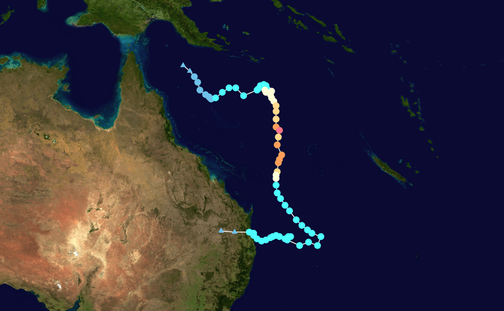
The tropical cyclone track of cyclone Alfred shows how it first was directed towards the open sea gathering immense momentum and strength from the warmer waters out at sea while then steering directly towards the coastal areas hitting landfall close to civilization causing massive economic damages from the ravaging of the coasts and cities nearby.
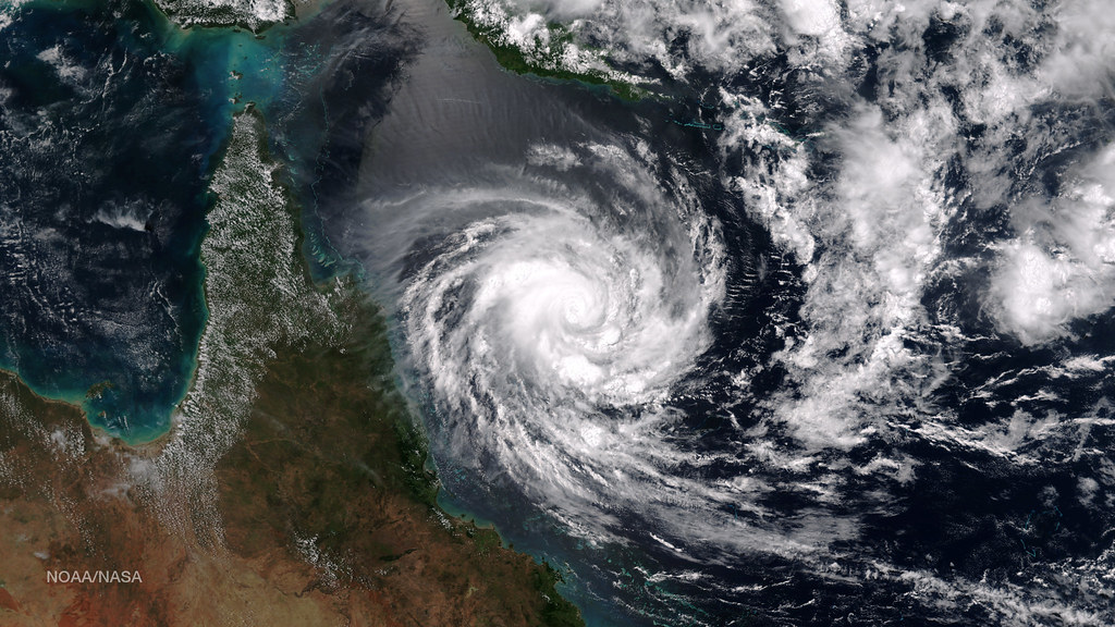
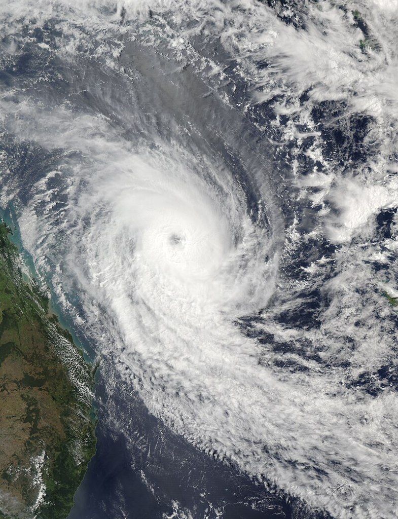
Satellite images showing true extent of cyclone
The satellite image technology developed by NASA and utilized worldwide by weather institutes enable researchers, meteorologists and the general public to easily understand what is going on a broader scale than was previously possible. This technology helps broadening the horizons for everyone involved including the people possibly effected by the consequences of such a devastating occurrence.
Furthermore it provides users with a stunning visual of the strong natural forces which are present at our world and how this contributes to the general physical environment which we are all trying to live in and by.
This type of imagery is important to broadly utilize and talk about across scales of the weather systems as they spark the interests of younger generations enabling them with a defined and nuanced purpose showing how exactly the different instances and occurrences of weather systems are happening. Lastly, they also help to promote understanding of the fundamental effects at play, such as the Coriolis forcing and the general roundness of the earth.
Related read: Impact of Ocean Currents on Marine Ecosystems, Trade and piracy
This fact that the massive and complex scales of the weather effects are common within the general public is crucial as misconceptions on the origins and mechanisms governing the general movement and behavior of weather systems are difficult to understand especially considering the interplay between how the winds are increasing in strengths and chaotic nature of the individual wind parcels.
Economic aspects of tropical cyclone Alfred
The economic damages of cyclone Alfred are difficult to exactly quantify but some estimates range the economic damages from the cyclone is in the areas of approximately 1.2 billion Australian dollars according to local news reporters who interviewed economists. This level of damage includes property, coastal and personal damage as a result of the natural catastrophe. Furthermore the tropical cyclone also caused a fatality and several other personal injuries from flying debris and similar hazards.
The economic damage from property and flooding as a result of the landfall of the hurricane is difficult to consider. There have been instances of damaged vehicles, broken trees and flooded streets as the general rainfall of the cyclone have exceeded 1.000 mm leading to one of the wettest instances of a tropical cyclone in modern history and especially considering the unfortunate landfall coinciding with the gold coast.
This catastrophe sparks new debate when considering the future prospects of the city how do we prepare for future catastrophic events mitigating landfall impacts of future cyclones and more importantly, how do we remedy the damage already present considering the high impact from cyclone Alfred.
The investments are needed immediately as the damages from the cyclone are fresh in mind. This way would enable the users to easily understand the possible consequences of natural disasters and why it is important to build and secure current assets from such future events.
Related read: Effective investment strategies for climate adaptation, Cloudburst in Roskilde
By making the effective investments in future scenarios and mitigation strategies at this point in time is crucial for ensuring that the future natural catastrophes will be mitigated in the future. The solutions for implementation can on paper look expensive however if implemented correctly the potential benefits are enormous as the long term effects ensures that future economic losses are mitigated effectively.
For the current disaster one of the main problems arising is the erosion of beaches across a broad scale where beaches have disappeared from existence and the general population therefore lacks access to the general proper beaches that gold coast is famous for.
Coastal erosion of gold coast beaches
Another important tragedy is the destruction and erosion of the famous beaches often found in that area where people usually bathe and surf around the area in question. The damage is particularly outspoken in the area near the gold coast where the beaches have been eroded significantly causing damage to the famous beaches.
The erosion is estimated to be approximately 2 m in the areas worst hit leading to exposure and inaccessibility for large majorities of the beaches. The remedy is drenching large amounts of sand offshore and nourishing the beaches leading to a large amount of sediment being moved offshore towards onshore. The build up of beaches from the now eroded beaches is difficult to accurately predict however they are build up during calmer weathers happening during the summer.
The build up is gradual and damage caused by the cyclone will take an immense amount of time before fully recovered since they are commonly build up slowly over the years and will properly take quite a while before the individual contributions of sand will be significant for the majority of the beach length.
References
7-news local source: https://7news.com.au/news/ex-tropical-cyclone-alfreds-damage-estimated-at-12-billion-c-18063806.

Leave a comment